Our reasons
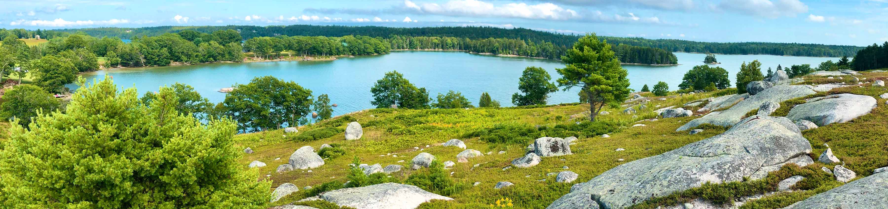
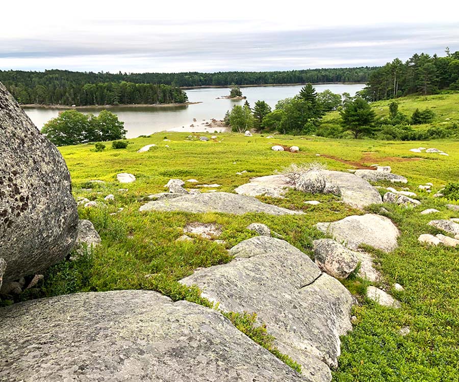
The old Kermit Allen blueberry barrens is a unique and defining piece of land in Blue Hill. Anyone who's driven past it along Route 172 or seen it from the water on the Salt Pond knows how special it is and that it should be preserved.
The Blue Hill Planning Board has 18 criteria that have to be met in order for a subdivision proposal to be passed. Below are some of the reasons we think this project should be rejected.
Aesthetic, cultural and natural values - #8
The proposed subdivision will not have an undue adverse effect on the scenic or natural beauty of the area, aesthetics, historic sites, significant wildlife habitat identified by the Department of Inland Fisheries and Wildlife or the municipality, or rare and irreplaceable natural areas or any public rights for physical or visual access to the shoreline; [PL 1989, c. 104, Pt. A, §45 (NEW); PL 1989, c. 104, Pt. C, §10 (NEW); PL 1989, c. 497, §8 (AMD).]
The Salt Pond barrens is a rare and irreplaceable natural area with unique scenic and natural beauty. It is for that reason that it was listed as one of the featured sites in the Hancock and Washington Counties' Downeast Coastal Scenic Inventory. The town would never consider allowing a 9-house subdivision on Blue Hill or next to the Falls (two of the other locations listed in the Inventory).
The barrens contain access to the mouth of Carleton Stream, which for generations has been fished by Native and commercial fishermen and women. The current proposal would allow access to be revoked at any time.
The Blue Hill Comprehensive Plan 2024 states that the town goal is to preserve the "rural, small town character" and "protect rural and waterfront areas from the impact of incompatible development." We believe that this proposal is an example of incompatible development. The Plan goes on to state: "While there are no immediate threats to Blue Hill’s natural and scenic resources, there is the risk of longer-term and cumulative damage through future development."
Pollution - #1
The proposed subdivision will not result in undue water or air pollution. In making this determination, it shall at least consider:
- A. The elevation of the land above sea level and its relation to the flood plains; [PL 1989, c. 104, Pt. A, §45 (NEW); PL 1989, c. 104, Pt. C, §10 (NEW).]
- B. The nature of soils and subsoils and their ability to adequately support waste disposal; [PL 1989, c. 104, Pt. A, §45 (NEW); PL 1989, c. 104, Pt. C, §10 (NEW).]
- C. The slope of the land and its effect on effluents; [PL 1989, c. 104, Pt. A, §45 (NEW); PL 1989, c. 104, Pt. C, §10 (NEW).]
- D. The availability of streams for disposal of effluents; and [PL 1989, c. 104, Pt. A, §45 (NEW); PL 1989, c. 104, Pt. C, §10 (NEW).]
The Salt Pond is an extremely delicate body of water with tremendous natural and economic value to the surrounding area. Not only is the Salt Pond used for recreation, but it is the home to significant aqualculture business, raising oysters, clams, and mussels. As the Comprehensive Plan states: "Salt Pond (and Carleton Stream flowing into it) should be a focus of continued efforts to identify the nature of any NPS pollutants and, if identified, to mitigate the flow of these pollutants into these water bodies. As discussed in the Marine Resources chapter, all of the Blue Hill areas licensed for aquaculture are located in Salt Pond."
Until 2022, the Salt Pond was listed by the Maine DEP as a "Threatened watershed." It is still listed as "Impaired." It doesn't take much to threaten the water quality of the Salt Pond and the businesses and jobs that rely on it. As the Comprehensive Plan: "one failed septic system .... could close a mudflat."
The barrens are quite steep and flow straight down into Carlton Stream and the Salt Pond.
The developer has provided NO studies to show how run-off from construction or the fully-developed site would impact water quality in the surround area. And they have not even looked as to whether the chemical fertilizers and pesticides that were used when the barrens were in commercial production are a threat.
Sewage Disposal - #6
The proposed subdivision will provide for adequate sewage waste disposal and will not cause an unreasonable burden on municipal services if they are utilized; [PL 1989, c. 104, Pt. A, §45 (NEW); PL 1989, c. 104, Pt. C, §10 (NEW); PL 1989, c. 497, §8 (AMD).]
All of the proposed lots would require above-ground, fill-based septic systems, many of them requiring additional pumping as the test pits sit above the proposed housing sites. And half of the proposed lots sit on land that is at the bare minimum of what the state allows for above-ground septic systems, hitting groundwater at just nine inches below the surface.
We believe the developer has provided insufficient information to prove that there is adequate drainage for even above-ground septic systems. And as noted above, it only takes a single failed septic system to pollute the pond for years.
Summary
Subdividing the barrens into nine individual lots would destroy an irreplaceble landscape and community resource. It would endanger both the water and wildlife and limit community access to Carleton Stream. We believe that the proposal should be rejected and instead, it should be preserved and maintained for future generations.
NEXT STEPS
We did it! But....we still have work to do.
Help us purchase the property.
Find out how to donate here.